Fort Campbell is a former military fort located near the small town (and modern popular tourist resort) of Mellieħa, on the northern coast of the island of Malta. The fort was built by British soldiers and army engineers between 1937 and 1938 to control this part of the Mediterranean Sea.
This area had been used as a control point since the Medieval period because of its excellent vantage point for the islands of Comino and Gozo. The British also constructed many pillboxes around the coastline of Mellieħa for defensive purposes in case of a German or Italian invasion. Although it was once a place of great strategic importance, today the fort lies in ruins.

Fort Campbell was once one of the most crucial fortifications north of the Victoria Lines, which is a line of fortifications dividing the northern and southern parts of the island and spans approximately 7.5 miles of the width of Malta. In the Maltese language, the fort is called Forti Campbell or Fortizza ta’ Campbell, but locals know it as Il-Fortizza tas-Selmun, because of its position on the Selmun peninsula. Fort Campbell was the last significant fortification to be built in Malta.

Situated at the approximate midpoint between Mistra Battery and the ruins of Għajn Ħadid Tower, the fort held a very important strategic position. It was constructed to protect the entrance to Mellieħa Bay, the entrance to the St Paul’s Bay, and it secured the landing of British seaplanes in Mistra Bay. The fort was constructed to replace the Wardija Artillery Battery, which had been built in 1915.

Before the construction of the fort, the site was visited by British Army officer and Governor of Malta Charles Bonham-Carter.
The building of the fort probably started in December 1937 and rushed to completion in the wake of the Munich agreement in September 1938. During World War II, the fort was expanded to include troops’ barracks and a radar system.


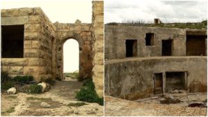
The main materials used for the fort’s construction were limestone and concrete. The design and the plan of the fort differ from older fortifications in Malta. Unlike the medieval strongholds built by the Knights Hospitaller and the polygonal Victorian forts built by the British in the 19th century, Fort Campbell was built to be more pragmatic than aesthetically pleasing. The fort was encircled by a thin wall and, instead of decorated gates, the fort’s entry was an opening in the perimeter wall defended by a guard room. Because of the new threat of aerial warfare, the buildings were positioned at a distance from each other.
The fort was also well camouflaged from the air–it was built so that from above, its walls looked like stones naturally positioned in the fields. It had two gun emplacements armed with 6-inch BL guns and a third gun emplacement, where 6-inch guns or a heavy anti-aircraft gun were probably placed. Several concrete machine gun posts similar to pillboxes and rifle loopholes were constructed around the perimeter wall. The main building was the Battery Observation Post. T
his building was used as a command center. It had a gun control room and a subterranean plotting room. The fort had a water tank, a few underground magazines, a generator room, direction posts, and bomb shelters. On the coastline, outside the perimeter wall, the Defence Electric Lights station and searchlight station were placed. In 1942, barracks for the infantry troops stationed in Selmun were constructed outside the fort. Romney huts were also constructed.
The fort had two gun emplacements armed with 6-inch BL guns and a third gun emplacement that likely also held a 6-inch gun or an anti-aircraft gun. Several concrete machine gun posts and rifle loopholes were dotted around the perimeter wall. The battery observation post was the main building and command center for the base. It had a gun control room and a subterranean plotting room. The fort complex was equipped with a water tank, a few underground magazines, a generator room, direction posts, and bomb shelters.
The defense electric lights station and searchlight station were positioned on the coastline outside the perimeter wall. In 1942, Romney huts and barracks for infantry troops stationed in Selmun were built outside the fort.

After the war, the fort lost its strategic importance but remained operational until the 1970s. Military guards were stationed there. The exact year of its demilitarization is unknown, but the site has been deserted ever since. Some of the buildings are still standing, but they are mostly in ruins.
The fort has been vandalized several times and the metal parts stolen over the years, which has contributed to the buildings’ collapse. The site isn’t closed, but there are no organized visits and some parts of the fort are unsafe. The local authorities have several ideas for how to revitalize the area and the fort, although no action has been taken yet.