Armazi is a significant ancient royal city and the original capital of the early Georgian kingdom of Kartali or Iberia. It is located near (approximately 2.5 miles) southwest of the modern town Mtskheta and 13.5 miles northwest of Tbilisi, the modern capital of Georgia.
The archaeological evidence shows that the old Armazi was a lot bigger than ancient Mtskheta.

The city had very important strategic position, mostly because it had ready access to the Daryl Pass (or Gate of the Alans), the main road over the Greater Caucasus.
This road was used by the Scythians and Cimmerians when they conquered the ancient Near East. It was also placed at the confluence of the Mtkvari (Kura) with the Aragvi river. Because of its position, Armazi controlled crucial trade routes and thrived in the early centuries of CE. It was destroyed by the Arabs in the 730s.

It is commonly believed that the name of the city and its dominant acropolis Armaz-Tsikhe (which means “citadel of Armazi”) comes from Armazi, the chief god of the pagan Iberian pantheon.
The name for the first time appears in the early medieval Georgian chronicles, but it is much older and it is reflected in the Classical Greco-Roman name Armastika or Harmozika, which can be found in the writings of Pliny, Strabo, Ptolemy and Dio Cassius. According to medieval Georgian documents, Armaztsikhe was found in the 3rd century BC by king Pharnavaz I of Iberia at the site previously known as Kartli.


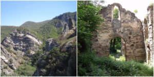
There were two great fortresses. One existed on the modern-day Mount Bagineti, on the right side of Mtkarvari river and the other was located at Sevsamora, or modern-day Tsitsamuri, on the left side of the river (north) and controlled the road towards Mount Kazbek. The fortresses stood just opposite each other defending and controlling the area.

Later, the near town of Mtskheta became capital of Iberia, but Armazi continued to be the holy place of Iberian paganism and the major stronghold of Mtskheta. The citadel of Armazi-Tsikhe was taken over by the Roman general Pompey in 65 BC, during the war actions against the Iberian king Artag.
A ruined structure over the Mtkvari river, called “Pompey’s bridge”, dates from that era. In fact, the highest peak Armazi had when Iberia was allied with the Roman Empire and the Roman Emperors. There are archaeological evidence that Roman Emperor Vespasian ordered strong fortification of Armazi for the Iberian king Mithridates I. The defensive wall was erected to block the southern doorway of the Daryal Pass and to protect the Roman frontiers from the frequent attacks of the Alans.
During this period Armazi was ruled by a hereditary pitiaxš, something like viceroy or satrap, who was second in the official Iberian hierarchy after the king. In the hereditary necropolis of this dynasty who ruled with the region were found engraved gems bearing portraits of two of these satraps: Asparukh and Zevakh. These are precious rare examples of the pre-Christian Georgian portraiture. Other authorities of whom there is record are the royal architect and the epitropos or lord chamberlain.

Armazi had a major role in the cultural life of ancient Georgia and in the development of the epigraphy in Georgia, many years before the invention of the Georgian alphabet in the 5th century. There are numbers of inscriptions found at Armazi.
The most crucial is the bilingual Greco-Aramaic gravestone inscription that honor the short life of the princess Serapita and her noble origins. It contains an atypical version of the Aramaic alphabet and it is widely known as the “Armazi script”, even though examples of this version of the Aramaic alphabet can be found in other parts of Georgia.

At the end of the 5th century or at the beginning of the 6th century Tbilisi became the Georgian capital during this era Armazi started to lose its importance. It still had its own military administrator. In 545 Armazi was governed by certain commandant Wistam. The city was completely destroyed in 746 by the Arabs and their commander Marwan Ibn Muhammad.

The city of Armazi wasn’t rebuilt again, but in the middle of 12th century, there was built the Georgian Orthodox monastery of St. Nino. Today the monastery is in ruins and only the 12th-century murals are still visible.

The archaeological excavations of the site so far have revealed the adobe town walls, towers, and several other structures. The land within the walls was terraced and different buildings were built on the terraces. There are identified three cultural layers: Armazi I (4th-3rd century BC), Armazi II (3rd-1st century BC) and Armazi III (1st-6th century AD). Armazi I includes a great hall of six columns with tiled roof. Armazi II is known by a temple with an apse. Armazi III is the richest layer. Among the survived buildings from this period are the royal palace, a bathhouse, a small stone mausoleum and a number of decorated tombs.

Armazi today is part of the open-air museum called National Archaeology Museum-Reserve of Greater Mtskheta.